Márcia Martins, 23, and Cláudio Pereira, 26, don't know each other, but both decided to take the information made available by Carris Metropolitana, translate it into data, and launch two web applications with more accessible interfaces.

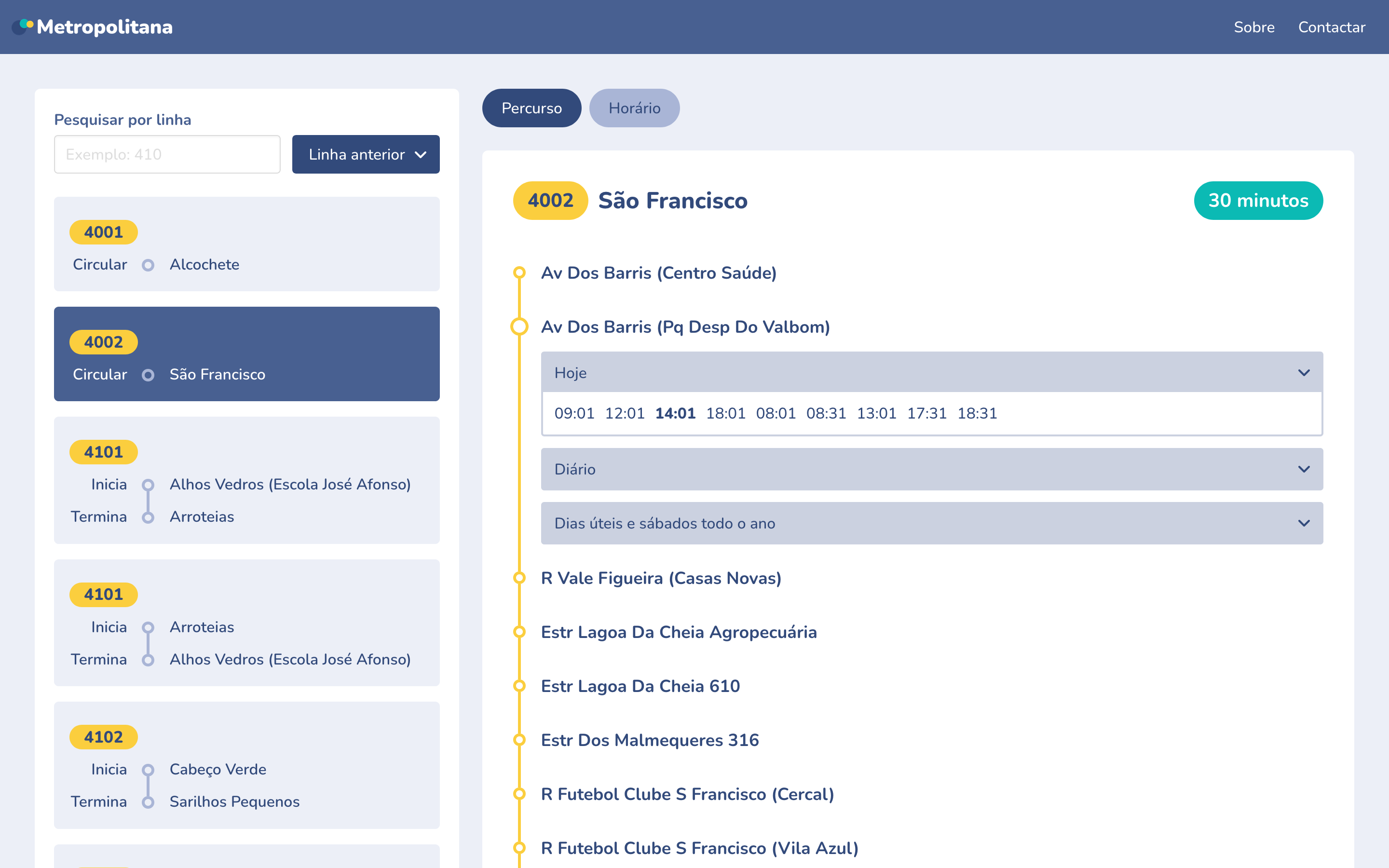
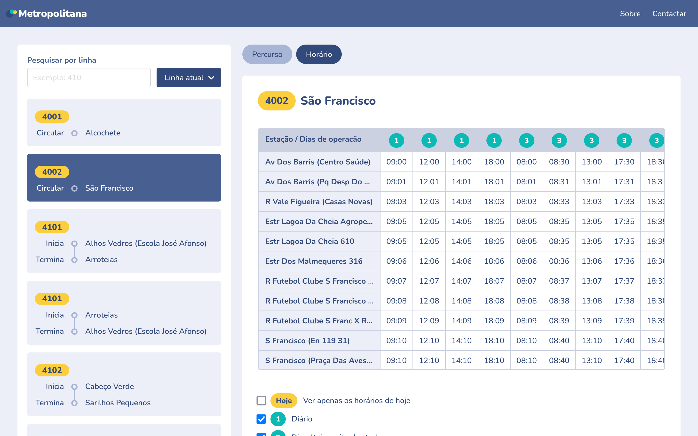
Márcia is 23 years old, lives in Loures and uses "public transportation to go almost everywhere, although unfortunately there are some places where it is complicated". She was excited about the launch of Carris Metropolitana (CM), but found the site impractical for searching lines, routes and schedules. So, decided to create a unofficial application, a Metropolitanthat can serve as an alternative.
More accessible schedules and routes
But right at the beginning, he encountered a difficulty: the absence of an official API of Carris Metropolitana (CM) that allows third parties to access updated information about the servicesuch as routes and stops, and integrate this same information into an external website or application. APIs in the field of transport and mobility can help stimulate innovation - with them, individuals, associations, and other companies can develop services that are in some way better than the official platforms and attract users. "Unfortunately it is quite common" the transport operators don't make APIs available, complains Marcia, who then decided to create one from CM's data to be able to create her application.
"Right now, I have a file with the original data on the server and will update it with some regularity, meaning it is a temporary solution and would not work if the data structure changes."he explains. "In the meantime, I was able to make the first version of the application with everything I was planning except the download of the schedules which will be the next feature. The last few weeks I haven't been able to devote time to the project, but it's nice to see that the CM website has already been updated and already has a usage more like what people are used to."
The first version of Carris Metropolitana's website presented a Line Converter and a timetable navigator that, from Marcia's perspective, were "a nightmare in terms of usability". His idea was to "create a more affordable alternative until there is a better solution provided by the CM itself". In other words, "a super simple application that would allow you to search for routes with both new and old numbers, view the route, look up the schedule, and download" - for, "for a large portion of people who only use one to two careers on a daily basis, and who don't have access to mobile data, printing schedules is super useful".
The work of Márcia Martins could even serve as inspiration for Lisbon Metropolitan Transports (TML)who runs CM, to update her site and copy some of her ideas. No problem, because the young programmer created everything in open sourceto "allow anyone to use the code and modify it as they see fit". "In an ideal world, and I have a feeling we are moving towards there, this kind of public data would be open, which would allow anyone to create applications with extra functionality according to their needs."mentions, "which would eventually benefit everyone and maybe even be adopted by the companies themselves in their official application".
Creative freedom
Claudio Pereira is 26 years old and a computer engineer, "student until recently". Refuses to ride in a car "on principle"when you don't have "need to do so"so he uses public transportation "for virtually every trip you have to make". He has always lived on the South Bank and currently makes his living between Barreiro and Lisbon, and says it only takes 45 minutes "from home to the center of Lisbon in a sustainable wayby bus, boat and subway, on a route that by car would be "bad" to do. On making data on public transportation services available, he believes it should be practical. "One of the biggest benefits of open data is that we don't know what it might result in; it's complete creative freedom available to an entire population"says. "People can take these things and make apps, produce national science, combine services, extend information. And the consumers of these works use them to improve their quality of life."
Claudio started doing something similar with Marcia, without both of them knowing each other's work. The young computer scientist also wanted "improve some of the launch gaps of the Metropolitan Carris" e "making routes, stopping places and transitory information available in a pleasant and accessible way, similar to what other operators have already gotten us used to".. With no official API and no access to privileged information (he asked TML but got no response), Claudio started by georeferencing the CM stops himself, manually, from the static information available on the operator's website. He also downloaded the schedules and saved them "in a computer-friendly format" analyze. "Computers handle large sets of information well", points out.
"There are immense possibilities for extending existing services with minimal amounts of effort. The generality of services do not seek to innovate, they seek to offer enough to satisfy their customers while preserving their interests, whether monetary or strategic"stresses. In the case of transportation, Cláudio points out that the websites of operators such as Carris, CP or Metro de Lisboa have "relatively aesthetic, relatively intuitive, relatively accessible pages, with a navigation flow that is relatively identical to all other operators, and therefore with few surprises for the user". The mobility companies "are not looking to create radical solutions that might work; rather, they are looking to ensure that conventional solutions work well"; but, according to Claudio, the CM site was not even a good solution.
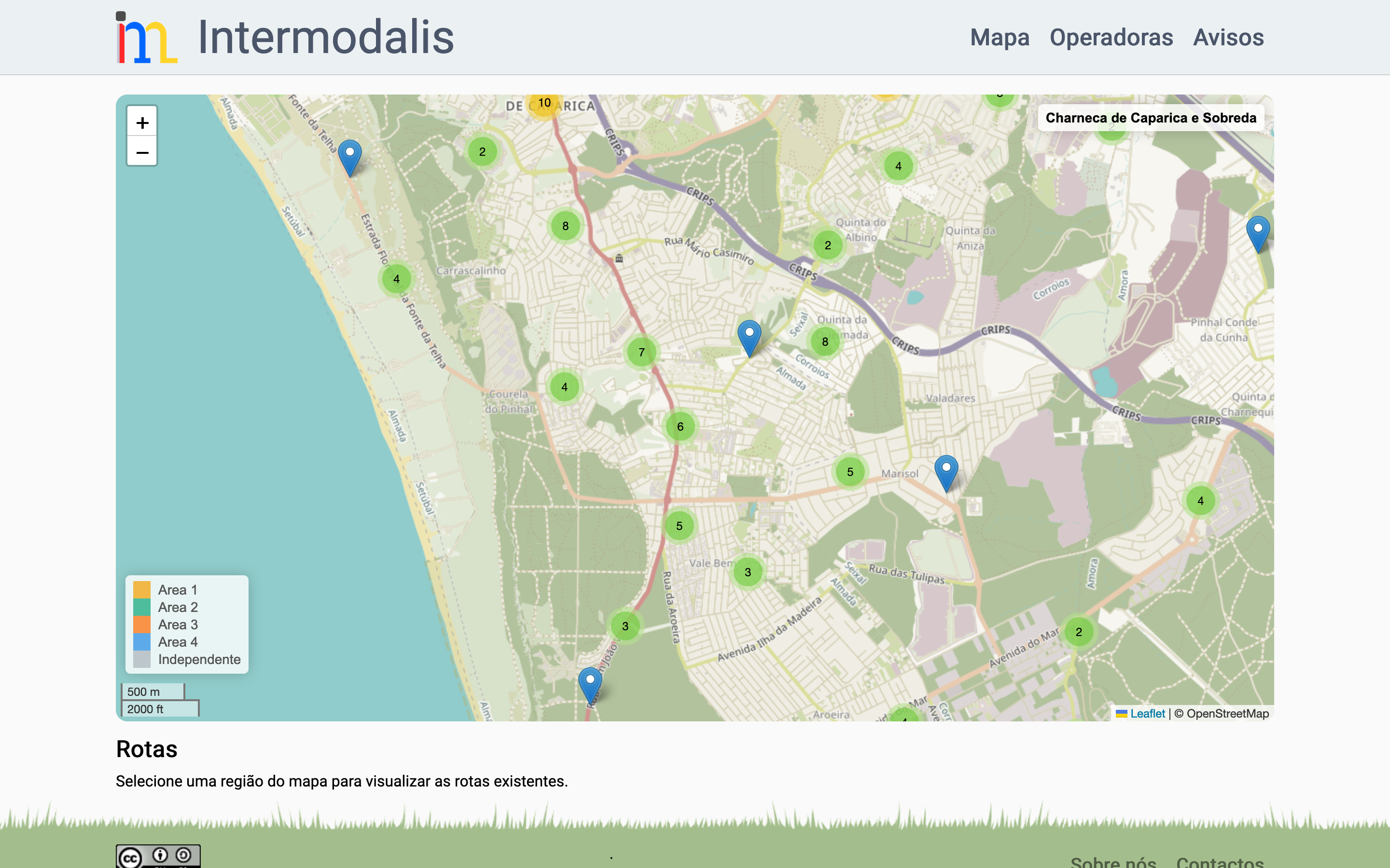
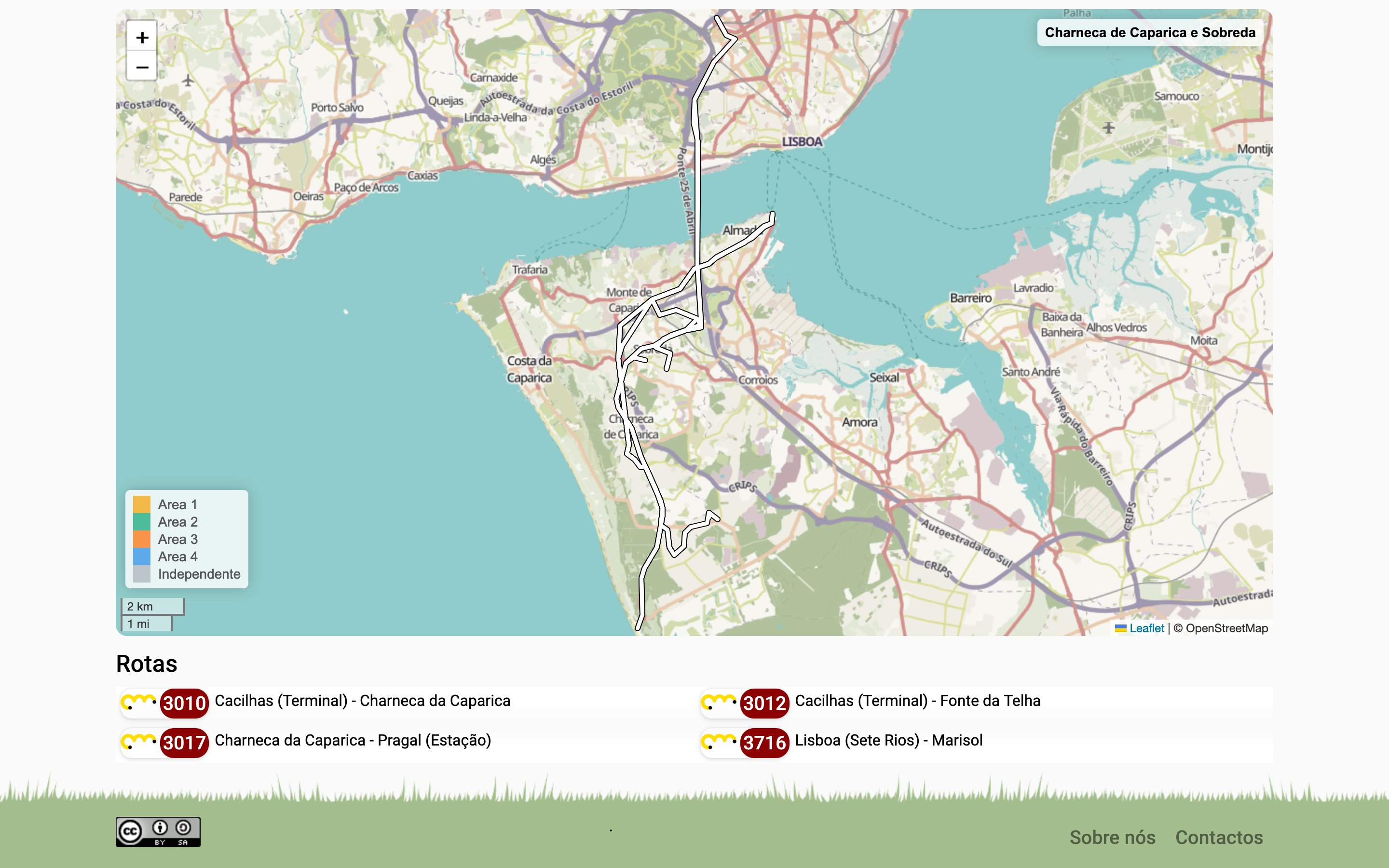
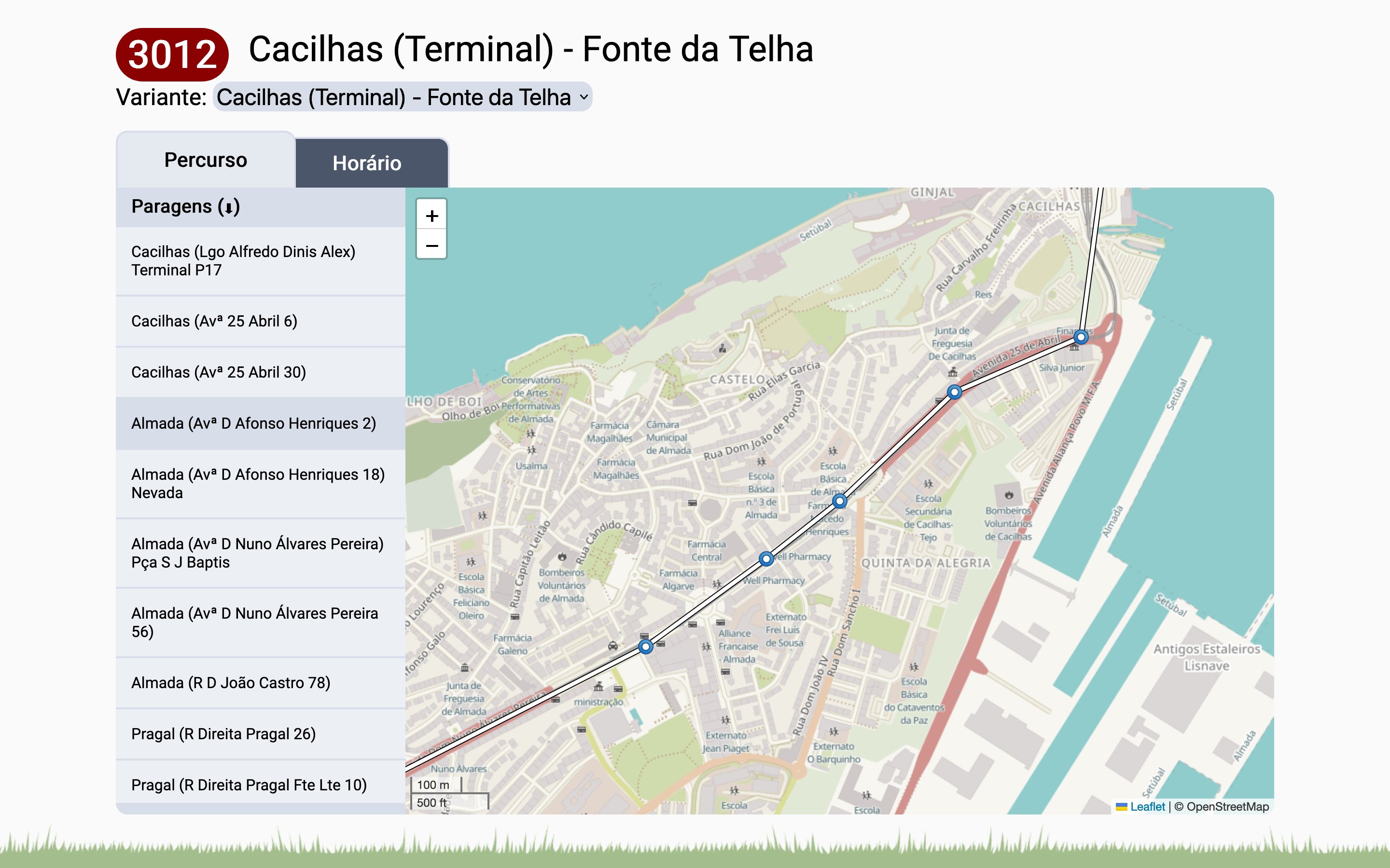
View the Network
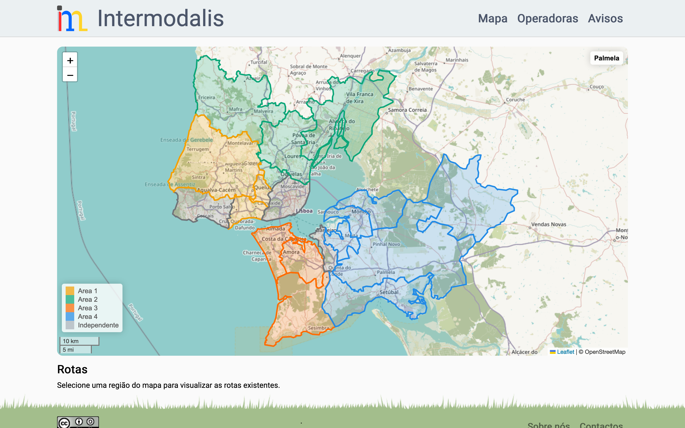
With your project IntermodalisCláudio's ambition is to create a map of the entire Lisbon Metropolitan Area public transportation network starting with Carris Metropolitana. For now it is possible to visualize the four operation areas and navigate through the two that are already available - Area 3 and Area 4. Zooming in on the map, one can see each stop already mapped by Claudio and the routes of the different lines. The platform allows you to click on one of the lines and see, in an isolated way, its route and schedule. "This information can in turn be channeled into other community projects, as the Open Street Map itselfbut until then it is necessary to mature the data, let people use it and confirm that it is indeed correct.he explains.
The basis of the Intermodalis é open source so that anyone can use and improve the work that Claudio has been developing in a voluntary way. "Not everything I've done has been published yet due to lack of quality, but as the project matures, I make it a point to make it reproducible, that is, to publish enough information that anyone with minimal effort can reach the point I'm at right now", points out. "I want to do my experiments and I want to allow others to do theirs. Who knows if we don't do something good that leads CM to improve their service... Who knows if we don't help some researcher... Who knows..." For example, "if there is an accessibility map where people who are blind or in wheelchairs know which stops give them the best conditions, those users gain something they didn't have before. It's a purely positive improvement".
Cláudio Pereira regrets that the launch of Carris Metropolitana didn't go as the expectations created in the population. "In my opinion, one of Metropolitan Carris' biggest mistakes was to assume that everything would work on June 1. It was to publicize everything on the eve and throw the buses out on the street...", understands. "This transitional period free of quality information should not have existed." The computer engineer points out that "it is not legitimate to consent to a drastic regression in the use of public transport, especially at a time when it is becoming increasingly clear that our planet will not easily forgive us"He feels that even though the operation of the Metropolitan Railway is not his responsibility, "there is a civic duty for my life to make a positive contribution to society". "If Metropolitan Carris makes my job unnecessary that's not bad, it's good. It's a sign that we've made progress." Cláudio Pereira is develop this project with the help of the Lisboa Para Pessoas Community on Discord.
Carris Metropolitana should have APIs with service information by the end of the year, along with a more sophisticated website and information within the future Navegante app. There are also still no GTFS format data CM updates, even though operator information is already available in apps like CityMapper.