The heavy rainfall of the last few days has raised questions about drainage and (im)permeabilization in the city. After all, what is the Drainage Plan? What does this Plan have besides tunnels? How can flooding be solved in one of the most waterproofed European capitals? Is this an effect of climate change? We go through documents and the...

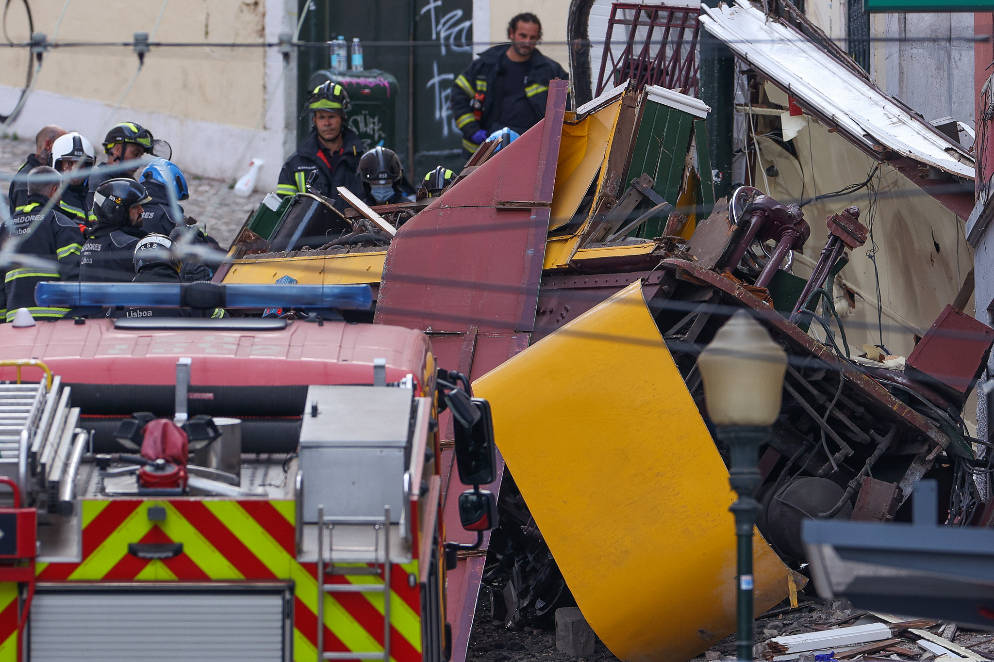
At the beginning of this month of December, Lisbon experienced hard times with days of heavy rain. One of the most critical moments was the December 7th night when high precipitation values were recorded in a short period of time, resulting in floods such as had not been seen for a long time in the Lisbon metropolitan area. In Algés a fatality is lamented and all over the region the damage caused by flooding is being taken into account.
IPMA data indicate that, in just one hour, more than 40 mm of rain fell - almost a third of the average total rainfall for the month of December in Lisbon (126.2 mm). It was in the meteorological stations of Tapada da Ajuda and the Geophysical Institute D. Luis, in Príncipe Real that the maximums were recorded that night: 47.8 mm and 44.5 mm of precipitation, respectively, in just one hour; 77.0 mm and 74.7 mm, if we look at a longer period of six hours. In the morning of that December 7th, the IPMA had issued an orange warning, the second highestfor the Lisbon district; at 10:26 pm, it updated it to red, the most serious alert level.
Days later, on December 13, another critical moment, with new highs in precipitation, according to IPMA.
"We have a decades-long history of terrible soil sealing. We have a structural problem in the city because a lot of it is built in flood bed, in places where it shouldn't have been built."acknowledged José Sá Fernandes in an interview in Night Edition of SIC Notícias, on December 8th. Sá Fernandes was the Alderman responsible for Green Spaces in the Lisbon City Council between 2009 and 2021. He has followed, therefore, the transformation of the city in the last decades. He also saw the floods of 2014. And he accompanied the elaboration of the Lisbon General Drainage Plan (PGDL).

After all, what is the Drainage Plan?
Lisbon's General Drainage Plan (PGDL) was originally conceived in 2008, at the time of Carmona Rodrigues' presidency, but revised years laterThe current version came into force in 2016, with a time horizon of 14 years - that is, until 2030. Basically, the Plan takes a snapshot of the current drainage system of the city of Lisbon and proposes new infrastructure to strengthen that system, while preparing it for a future of climate change.
"There was an idea of Carmona Rodrigues to make a Drainage Plan consisting of several tanks that would retain the water. After consulting the greatest Portuguese and foreign specialists, it was realized that this was not the way to go and a new Drainage Plan was drawn up to be implemented.explained Sá Fernandes on SIC Notícias. "That Plan advises the tunnels but advises other measures."
The original Plan of Carmona Rodrigues (independent, supported by the PSD) had 2006-2008 as a time horizon and included two major works: on the one hand, the construction of several reservoirs in the high parts of the city, to attenuate the water from heavy rains that would reach the lower areas of the city and cause flooding; and on the other hand, the creation of a micro-tunnel between Avenida Almirante Reis and Santa Apolónia to conduct water to the Tagus RiverCarmona Rodrigues, for not being able to build a reservoir in Martim Moniz because there was an underground parking lot there. With Carmona Rodrigues, Lisbon gained a drainage plan for the first time in the then last 40 years.

In the following years, the Lisbon City Hall, then led by António Costa (PS) in two mandates, could not financing for the execution of the Carmona Plan, which involved an investment of 160 million Euros. In 2015, a revision of the old Drainage Plan is announced by the new mayor, Fernando Medina (PS), with the release of the current version. The PGDL, the acronym by which it came to be known, went through a period of public consultation until it was approved at a City Council meeting in December of that year. The new Plan:
- is more ambitious in thinking in 100 years instead of 10. This means that the infrastructure built under the Plan, is ready for a lifetime of 100 years;
- starts talking about climate changein an attempt to prepare the city of Lisbon for a scenario of more heavy and intense rainfall in short time intervals;
- changes the strategy: Instead of building reservoirs, the new plan relies on the creation of retention basins and the construction of large collectors (the tunnels) that can take the excess water directly to the Tagus.
With no possibility of financing the execution of the Plan with European Union funds, the Lisbon City Hall turned to the European Investment Bank (EIB) for a loan totaling 250 million euros, divided into five tranches to execute the PGDL and, among other interventions, to build the two long-awaited tunnels - the most expensive and complex part of the entire Drainage Plan.
Calendar
- 2004/06 - The public tender for the elaboration of the Plan was launched and the task was awarded to the Chiron/Engidro/Hidra consortium;
- March 2008 - presentation of the first Drainage Plan, with a 10-year perspective, which was not executed in the following years due to lack of funding;
- 2015 - review of the previous Plan and presentation of a new proposal, the Lisbon General Drainage Plan (PGDL) 2016-2030. New plan extends the time horizon from 10 to 100 years and changes the strategy of the previous one: retention basins instead of reservoirs, and construction of two large drainage tunnels;
- 2017 - construction of the tunnels is subject to an Environmental Impact Assessment, with a public consultation process. A loan from the European Investment Bank (EIB) for the implementation of the tunnels, in particular, and the Plan, in general;
- 2018 - first attempt at a public tender for the tunnels. Attempt failed due to the low base value proposed (106 million);
- 2019 - relaunch of the public tender, with a new base value of 140 million.
- December 2020 - conclusion of the public tender and award of the work for 132.9 million to the Mota Engil/SPIE Batignolles Internacional consortium;
- April 2021 - signing of the contract;
- 2022/23 - consignment and start of the work.
After the tunnel design and construction projects have been drawn up, and an Environmental Impact Assessment phase, carried out still in 2017was the international public tender was launched to find someone to execute the work. In 2018, this tender, with a base value of 106 million euros, was deserted, that is, with no bids. It was then re-launched in 2019 with a new base value of 140 million. In December 2020, the tender is closed and the work is awarded for 132.9 million to the consortium formed by the companies Mota Engil and SPIE Batignolles International. The contract is signed in February 2021 by the then Vice-President of the Lisbon City Hall, João Paulo Saraiva (PS), from the executive led by Medina. In 2022, the work goes ahead under Carlos Moedas.

What does this Plan have besides tunnels?
In simplified form, the new PGDL proposes to control the water at the source, through basins that retain it and promote its infiltration into the ground in the high parts of the city, and through tunnels, conduct the excess water to the river, thus avoiding flooding. The construction of two underground tunnels to take water directly to the river is just one part of the Drainage Plan, which has been underway since 2016.
The Plan includes the following major interventions:
- two large tunnels of 5.5 meters internal diameter, one between Santa Apolónia and Monsanto (5 km) and another between Chelas and Beato (1 km), in order to capture excess water in specific areas and discharge it directly into the Tagus, avoiding flooding and protecting the lower areas of the city. This is the most significant work of the PGDL and represents an investment of 140 million euros;
- two large open-air water retention basinsone in Ameixoeira, built in 2018, and another in Alto da AjudaIt will be built in 2019. In addition an intervention by Parque Eduardo VIIThe project will be completed in 2021 to improve the capacity of this green space to retain water. The retention basins help slow the access of water to the city's drainage collectors, allowing no excess water to enter the underground tunnels. These basins also have an infiltration function, allowing accumulated water to seep underground instead of being drained into the river;

- a micro-tunnel at Parque das NaçõesThis 325 meter long, 1.2 meter internal diameter and 9 meter deep collector takes water from a basin near Gare do Oriente (Avenida de Berlim) to the Tagus River. The construction of this small collector was completed in 2020. Five rainwater discharge points in the Tagus were also improved in the Parque das Nações area;
- the connection of retention basins already created in several parks and gardens to the city's drainage system. Namely: West Park, Campo Grande, Quinta da Granja, Vale Fundão and Vale de Chelas. This intervention is still to be done;
- various works on the current drainage system (reinforcement of collectors, improvement of surface runoff with gutters/sumidouros, flow controls, etc.). This part of the plan is still mostly to be executed.
Before the General Drainage Plan began to be executed, Lisbon carried out some interventions in this area. On the one hand, the sewage in the Tagus (Lisbon's major water receptor) was stopped, with all the so-called domestic wastewater being sent for treatment at a WWTP. There were also interventions in the lower areas of the city to improve the discharge of rainwater into the river, and rainfall and flow meters were installed in the collectors. According to Sá Fernandes, work was also done at the level of soil sealing: "Since 2008, we no longer allow soil sealing. We stopped all those lots that were planned in valleys, in floodbeds, in places with water basins.he explained in the same interview, giving the Vale da Montanha - between Areeiro and Chelas - as an example of where an urban park integrated in a green corridor has been created. "We got a PDM, which has been in place since 2012, to make that rule [of no waterproofing] clear to everyone."

The PDM, in force since 2012, effectively talks about promoting the "increasing permeable areas in public space, as a contribution to increasing soil permeability in the city"or the "increasing the presence of greenery and permeable area in the city, particularly in public space, block interiors and garage roofs"with the same goal in mind. It also talks about "protection of the permeability of the terraces" and in "formalization of ecological corridors"In the past, the PDM (Plano Municipal de Formação de Montanha, or PDM in Portuguese) was developed to protect some areas where today there are green and urban parks - Vale da Montanha, Vale do Fundão, Rio Seco, etc. But the PDM also "liberalized the uses of the soil, opening the door to excessive and inappropriate occupations. We urgently need to change course, adequately planning the city's soil occupation, reversing or correcting situations that induce risk". - words of the current PCP Councilman in the Lisbon City Hall, sent to the editors at the time of the recent floods. Criticism that PEV had already made in 2018 in the Municipal Assembly, when it approved a recommendation for the "appreciation and preservation of the Soil as a fundamental resource in the city".
Drainage beyond the Plan
In any case, in a city, drainage is important for the city regardless of the changes we experience and experience living in the climate. The now Lisbon General Drainage Plan (PGDL) seeks to modernize and improve the city's existing drainage system. Yes, Lisbon does, of course, have a drainage system. It is a large system, consisting of basins, collectors (tunnels) and other equipmentand seeks to infiltrate rainwater (from the rain) into the subsoil or to retain it and lead it to the river. If the city drainage has a whole infrastructure that escapes our view because it is underground (the case of the collectors) or because it is visible only when it rains (the case of the basins), there is an important part of it that we step on every day: the gutters or drains, into which the water drains from the sidewalks and roads.

Lisbon's drainage system is actually divided into three - one for each hydrographic area of the city. Each system is composed of water collection points (the so-called rainwater), a network of collectors that transports it, a water treatment plant where this water is treated, and discharge points into the Tagus River:
- o Alcântara's drainage systemwhich serves the municipalities of Oeiras and Amadora, but also a large part of Lisbon. It is the largest drainage system in the city, involving the entire area of Algés, Alcântara, Ajuda, Belém, Cais do Sodré, and also Benfica, Campolide, Avenidas Novas, Avenida da Liberdade and its surroundings, the axis of Avenida Almirante Reis and Martim Moniz, the city center, and Alfama. This system is made up of several collectors (tunnels) that carry the water collected to the Alcântara Channel, which unites the waters of the old Alcântara stream with residential waters (known as sewage) and rainwater from the areas mentioned; the Alcântara Channel is connected to the Alcântara Water Treatment Plant where all the water is treated before it reaches the Tagus River;
- o Chelas' drainage systemwhich borders on the Alcântara in Santa Apolónia and takes in all the riverside part of the city up to Olivais. It also receives the waters from Graça, Penha de França, Chelas, Bela Vista, Campo Grande, Alvalade, Lumiar, Alta de Lisboa and Santa Clara. To the north, it is bordered by the Odivelas drainage basin. The Chelas system is associated with the Chelas WWTP;
- o Beirolas' drainage system includes all the parish of Olivais and Parque das Nações (including Moscavide and Sacavém), a part of Beato and Marvila, Lisbon Airport and a part of the municipality of Loures. It is associated with the Beirolas WWTP.
The most common water catchment points are the gutters (or drains), into which the water flows that the collectors carry to the treatment plants for treatment - from here are discharged into the river (not always but we will get to the exceptions).

Lisbon, a waterproof capital city
Sá Fernandes sees the construction of the drainage tunnels as "a redundancy" because, it says, "we can no longer permeabilize what has been waterproofed". "I would much rather take land that is impervious today and make it permeable, but in view of the city we have [the construction of the tunnels] is an inevitability"said the former councilman.
According to a review by the European Environment AgencyThis was done with satellite images from 2006 and shared in 2011, Lisbon is the fourth most waterproofed city in Europe - is behind Bucharest (Romania), Tirana (Albania) and Warsaw (Poland). The Portuguese capital has 60.66% of your impermeable soilI mean, occupied by buildings, parking lots, asphalt and other infrastructure that prevent water from infiltrating.

It is in this context of waterproofing that the PGDL can be important, capturing the water that cannot get into the ground and carrying it through highway-style tunnels to the Tagus. In essence, it is "passing the water from point A to point B and pouring it into the river quickly, when we need it, because it is an increasingly necessary resource"says Aurora Carapinha. For the landscape architect, a disciple of Gonçalo Ribeiro Telles, the PGDL cannot be a unique solution for flooding and is not enough on its own. "We have to make water cycle management plans and have planning policies that realize that the territories cannot support infinite construction. Soil and water resources are fundamental in urban political management".said in an interview to Público.
In this short conversation, Aurora Carapinha explains that it is important to permeabilize upstream of flood zones (i.e., in the high parts) to promote water infiltration into the soil, but also to permeabilize the low parts (which tend to flood) for the same reason. "It's enough to have more green areas in certain zones, more gardens, which doesn't mean taking away all the roads or lanes. For many years, attention was drawn to the need to not waterproof the terraces in downtown Pombalina, in Lisbon, which let water enter the ground."he said. "The more water that goes into the soil the better, because we're using the methods of the water cycle. It's making sure the water doesn't get lost, because it's silly for us to lose all this water that we've rained."

Right at the beginning of the multi-page document that the General Drainage Plan consists of, it is stated that this Plan is not the only solution to flooding, but that action must be integrated with "with the development of the city recommended in the Municipal Master Program (PDM), with the good policies on climate adaptation and with the actions foreseen in other programs under development in the city". In other words, this Plan will not solve everything when it comes to flooding, mainly because Lisbon is a highly impermeable city. However, the Lisbon of 2006 is not the same today. In recent years, green corridors have been designed and some have been realized; new urban parks have been created; small retention basins have been built in various parts of the city; land has been reserved for urban agriculture.


The recent transformation of Praça de Espanha into an urban park - named after Gonçalo Ribeiro Telles - is an example of the adaptations Lisbon has been making. Today there is a large central lawn that, on rainy days, becomes a lake - water accumulates and is held back while it cannot infiltrate the ground or flow downstream. Yes, in Praça de Espanha there is also a temporary stream on rainy days, allowing the water from the lake and other water that runs through there to be directed into the drainage system; from there it enters the Alcântara network and ends up in the Caneiro. On these days of heavy rainfall the retention basin at Praça de Espanha proved its function most, despite the fact that its surroundings continue to flood. We are talking about flooding not only on Avenida de Berna but also at the new road intersection at the Plaza, where there is a problem in conducting these waters to the new retention basin.

In the interview we have already quoted, Aurora Carapinha reminds us that Lisbon is based on several creeks, as its toponymy indicates. "On Avenida de Berna, for example, the Rego ditch used to pass, and that's why there is the Rego Hospital there. This Rego ditch received all the water from the São Sebastião da Pedreira hillside and from that area.he says. "The streams [in urban areas] cannot be cut off. It doesn't mean they have to undergo renaturalization processes, but we have to respect the flow of water from the high points to the lower ones." Throughout its growing years, Lisbon hid its creeks - they were plumbed somewhere under the streets and avenues. There are more examples than the one Aurora gave. The Arroios stream that runs along the Almirante Reis axis, the Valverde stream that lives under the Avenida da Liberdade, or the Alcântara stream that runs along the Alcântara Canal, which we have already talked about, mixed with domestic sewage.
Bringing these or similar watercourses to the surface, integrating them into the city's public space, can also make sense in a logic of renaturalization of the city itself. This discussion took place in Alcântara when, in 2021, the Free Party proposed recovering its creek, separating it from domestic wastewater and removing it from the Caneiro. The idea was to place the creek running along Avenida de Ceuta, in the Green Corridor of Alcântara Valley that has yet to be completed, something that the original project does not foresee (the plan is to create an artificial watercourse, fed by the Alcântara Wastewater Treatment Plant).

Also in the new Plaza de España would be planned renaturalization of the Ribeira do RegoToday it is hidden under the ground. "The proposal advocates the renaturalization of the natural water path, promoting the installation of a wet ecosystem, in coexistence with the other systems of the city, naturally bio diverse, productive, with all the benefits that come with it, a cleaner atmosphere, gardens easier to sustain, a fresher city, more resilient to climate change, a more beautiful city"The project's concept description, signed by the landscape architecture firm NPK, reads.
Bringing water back to the surface of the city at certain times and in certain spaces means increasing the permeability of the city, but also making it more pleasant with new areas to be and enjoy the biodiversity that will inevitably gather around these waterways. The way we pave the city has a lot to do with this issue of valuing water and promoting its infiltration underground. Car parking lots, for example, can and should have a permeable floor that allows rain to enter between cement blocks instead of a tar floor. And on some city streets, particularly neighborhood streets, we can use granite blocks instead of asphalt to not only invite motorists to slow down, but also to allow water to seep in.

And yes, the green corridors. We have yet to talk about them. Idealized many of them by Gonçalo Ribeiro Telles, the green corridors are groups of urban parks that are connected to each other and where you can walk, cycle, enjoy nature, cultivate, play sports, relax, play... Many of these corridors fill valleys, as is the case of the Eastern Green Corridor, which connects the urban parks of Bela Vista, Vale da Montanha, Casal Vistoso, Vale de Chelas, Vale Fundão and Quinta das Flores, and ends at the Parque Ribeirinho Oriente, next to the river and in turn connected to the whole riverside area of Parque das Nações.
In many of these corridors and parks, retention basins were created. We have already talked about them associated with the PGDL, but most of these basins existing today in Lisbon are not directly connected to the drainage collectors, serving mainly to accumulate water and promote its slower infiltration. In fact, retention basins have this important function of attenuating the flow of water that would run off into low areas, causing flooding, or that would exhaust the capacity of the collectors and the drainage network. These basins can also have an anti-pollution function, "guarding" stormwater (which may be polluted or contaminated) when treatment systems are unable to cope with the inflow.

Climate change?
If heavy rains, with intense waterfalls in short time spans, have always happened, climate change will make them more frequent. Lisbon has a Climate Action Plan (CAP)It was developed in 2021 and has a time horizon of 2030, with a Municipal Strategy for Adaptation to Climate Change (EMAAC)2017 document, and then there is the Metropolitan Plan of Adaptation to Climate Change of the Metropolitan Area of Lisbon (PMAAC-AML). In all the documents, it is unanimous: Lisbon, the city and the region, will be affected by heavy precipitation events, which will occur more often and with greater magnitude, and by the increase in the average sea level. It will therefore be more susceptible to flooding and inundation. And so it will be essential that cities like Lisbon prepare themselves with more effective drainage systems to help that the water that falls, and which tends to go into the lower parts of the city, can be properly routed.
One of the first parts of the PGDL reads, in this sense:
"Flooding situations are frequent, particularly in low and flat areas of the city and located downstream of large catchment areas with significant occupation, as is the case of the low-lying areas of Alcântara and Chelas. The drainage networks of these areas, close to the estuary, are subject to the tides and have a reduced gravitational availability for the flow of flows generated upstream. The situation is tending to get worse due to the growing occupation of territory and the effect of climate change, particularly with regard to the increase in the average sea level and the increased probability of extreme precipitation events. These situations constitute particularly difficult challenges to resolve."
- PGDL 2016-2030
But climate change poses a challenge also for the drainage systems themselves. On the same front pages, you can read:
"The impacts of climate change on the drainage system are, above all, associated with the rise in the average sea level in the lower areas of the city of Lisbon and the possible increase in the frequency and magnitude of extreme precipitation phenomena, of short durations. Added to this is the impact of the increase in the variability of the precipitation regime, with the probable increase in the duration of dry periods which, associated with the increase in air temperature, will condition the self-cleaning conditions of the collectors and provide the occurrence of odors, toxicity and corrosion."
- PGDL 2016-2030
The floods and inundations we have seen in recent days, due to intense levels of precipitation in short periods of time, can make us look at water and its presence in the city with new eyes. And they can also make us identify and appreciate the drainage network in its different forms, something that might otherwise pass us by in our busy daily lives. Let us take a lesson from all this: what is drainage, what are basins, and what can be done to take better care of our water.